Developing story — last updated 7:10 p.m. PT
843 acres, 0% containment. Mandatory evacuation orders in effect for zones LAC-E018 and LAC-E030-B.
CAL FIRE calls the Bouquet Fire an immediate threat to life. Aircraft were released at nightfall because of low visibility and are expected back in the morning. Check the Genasys Protect evacuation map for the latest zone status before traveling in the area.
SANTA CLARITA, Calif. — A fast-moving brush fire exploded across the mountains northeast of Santa Clarita on Saturday, growing from a wisp of smoke to an 843-acre inferno with zero containment in a matter of hours — and forcing mandatory evacuations that fire officials say pose an immediate threat to life.
The Bouquet Fire was first reported Saturday afternoon near Bouquet Canyon Road and Quarry Road, in the Angeles National Forest. Initial dispatch reports put the first call just after 2:30 p.m.; CAL FIRE's incident log lists the fire at around 3 p.m. What happened next was a textbook example of how fast Southern California brush can go from a spark to a siege: the fire was estimated at roughly 5 acres when crews arrived, ballooned to 20 acres within minutes, hit an estimated 100 acres by about 3:30 p.m., surged to roughly 710 acres by 4:52 p.m., and reached 843 acres by early evening — all with 0% containment, according to CAL FIRE.
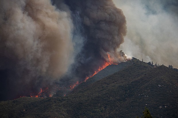
It was burning north through light-to-medium brush at a moderate rate of spread when firefighters first sized it up, with structures already threatened. By nightfall, officials said structures and power lines were threatened and crews were also battling two spot fires near the main blaze. Video from the region showed a towering plume of smoke billowing above the mountains — visible for miles across the Santa Clarita Valley.
Key facts
The evacuation orders
Late Saturday afternoon, CAL FIRE issued mandatory evacuation orders for the area around the fire, saying it posed an immediate threat to life. The orders covered zones LAC-E018 and LAC-E030-B in the remote mountainous corridor where the fire ignited — country of steep canyons and narrow ridgelines in the San Gabriel Mountains, where vehicle access is limited and fire can move faster than engines can follow.
By about 5:30 p.m., authorities said some evacuation orders had been downgraded to warnings — a sign that firefighters had managed to steer the fire's edge away from at least some threatened areas, though officials stressed the situation remained dangerous and fluid. Evacuation alerts remained in effect into the evening, and incident commanders requested law enforcement support to help carry out evacuations as the fire continued to move.
Anyone in the Santa Clarita area should check the Genasys Protect evacuation map — the official, live source for which zones are under orders versus warnings — rather than relying on social media posts, which can lag hours behind conditions on the ground.
The firefight, on the ground and in the air
Firefighters attacked the Bouquet Fire from the ground and the air from the first hour. Water-dropping helicopters and air tankers worked the flames from above as ground engines and hand crews tried to find anchor points in punishing terrain. The rugged canyons of the Angeles National Forest restrict vehicle access along much of the fire's edge, forcing firefighters to rely heavily on hand crews cutting line along narrow ridgelines and helicopter water drops where engines cannot go.
As darkness fell, CAL FIRE made the call every wildfire commander dreads: the aircraft were released because of low visibility, with plans to return in the morning. Night flying over steep, smoky terrain is among the most dangerous work in firefighting, and the decision — while it slows the air attack — is standard practice when pilots can no longer see the ground they are trying to protect. Ground crews continued working through the night.
Two spot fires — new ignitions sparked by embers thrown ahead of the main fire — added to the workload, each one a potential new front if not caught quickly. Spot fires are a signature danger of wind-driven brush fires: embers can sail hundreds of yards over containment lines and start fresh blazes in unburned fuel.
A heat wave doing the fire's work for it
The Bouquet Fire did not arrive on an ordinary October day. An extended heat wave has gripped Los Angeles County and most of Southern California, and the weather station nearest the blaze told the story: 93 degrees, 21% relative humidity, with 7 mph winds gusting to 18 mph out of the northeast at around 3:30 p.m. — right as the fire was making its big run.
Prolonged heat dries out vegetation, turning chaparral and brush into highly receptive fuel. When that combines with the low relative humidity typical of inland canyon systems during heat events, fire behavior becomes erratic and difficult to predict — exactly what crews saw Saturday as the fire repeatedly outran its estimated size.
The National Weather Service added one more variable to the overnight calculus: a southwest onshore wind shift of 6 to 8 mph, gusting to 13 mph, was expected at the fire between 5 and 6 p.m. Saturday, persisting for a few hours before switching back to a light offshore breeze later in the evening and overnight. Wind shifts like that can turn a fire's flank into its head in minutes — which is why incident commanders plan the night shift around the forecast, not the current conditions.
Roads closed, cause unknown
The California Highway Patrol closed Bouquet Canyon Road at Vasquez Canyon Road as emergency crews poured into the area, and incident commanders requested additional closures at Spunky Canyon Road and Texas Canyon Road. Drivers are urged to avoid the area entirely — not just because of the closures, but because fire equipment staging along narrow canyon roads leaves no room for sightseers, and conditions can change in minutes.
What started the fire remains unknown. The cause is under investigation, and the U.S. Forest Service has jurisdiction over the incident since it began inside the Angeles National Forest. Officials had not reported any injuries or confirmed structural damage as of Saturday evening — the story so far is one of threat, not loss, and firefighters were working to keep it that way.
What to do if you are nearby
If you live in or near the evacuation zones: take mandatory orders seriously and leave when told — "immediate threat to life" is not language fire officials use lightly. Check the Genasys Protect map for your zone's current status, since orders and warnings were being adjusted through the evening. If you are under a warning rather than an order, be ready to leave on short notice: pack essentials, keep your car fueled and pointed out, and have a plan for pets and family members who may need extra time.
Even well outside the evacuation area, the smoke plume is affecting air quality across parts of the Santa Clarita Valley. Limit outdoor exertion if you smell smoke, keep windows closed, and check on neighbors — especially older residents — who may not be following the updates.
This is a developing story. Previously will update this page as CAL FIRE releases new acreage and containment figures and as evacuation zones change.
Reporting this story is based on
- Fast-moving wildfire explodes in size near Santa Clarita as extreme heat wave grips SoCal
New York Post — 2026-10-03 - LIVE: Bouquet Fire near Santa Clarita triggers evacuations
FOX 11 Los Angeles — 2026-10-03 - Evacuations underway as wildfire near Santa Clarita grows to 800+ acres
NBC Los Angeles — 2026-10-03
Acreage (843) and 0% containment via CAL FIRE as reported by the Los Angeles Times and NBC Los Angeles (Oct. 3, 2026); growth timeline (5 to 843 acres) via Watch Duty and CAL FIRE as reported by the New York Post (Oct. 3, 2026); evacuation zones LAC-E018/LAC-E030-B via FOX 11 and the New York Post (Oct. 3, 2026); "immediate threat to life" via CAL FIRE as reported by the Los Angeles Times (Oct. 3, 2026); order downgrades, aircraft release, weather-station readings and NWS wind forecast via NBC Los Angeles (Oct. 3, 2026); road closures via the California Highway Patrol as reported by NBC Los Angeles and FOX 11 (Oct. 3, 2026); cause under investigation and U.S. Forest Service jurisdiction via the New York Post (Oct. 3, 2026). Hero image is a file photo from a November 2024 California wildfire, not the Bouquet Fire.