The Short Version
- As of 1 p.m. ET Friday, Isaias had 120-mph winds — a Category 3 — located about 160 miles south of Pensacola, moving north-northeast at 16 mph, and the National Hurricane Center expects it to make landfall Friday evening as a Category 3 or near it, near or just east of Pensacola.
- Life-threatening storm surge of 6 to 9 feet is forecast along the western Florida Panhandle coastline from Escambia County to Indian Pass, with water levels rising this afternoon, peaking Friday night, and subsiding after midnight.
- Tropical-storm conditions have already started along the Northern Gulf Coast, the NHC said, adding that preparations against life-threatening surge and devastating winds should be finished in the next couple of hours.
- A Tornado Watch is in effect for Pensacola and all of Santa Rosa County until 8 p.m. CT, with the tornado threat increasing this afternoon and continuing overnight, greatest east of the storm's center.
PENSACOLA, Fla. — Isaias is done climbing and has arrived as the thing forecasters were worried about all week. The 1 p.m. ET Friday advisory from the National Hurricane Center put the storm at 120 mph — officially a major hurricane — centered about 160 miles south of Pensacola and moving north-northeast at 16 mph, faster than before, with central pressure down to 959 millibars. This is the Friday-afternoon update on a storm we've been tracking all week and that hit Category 2 on Thursday night — and the message from the hurricane center has gone from "prepare" to "finish."
The forecast now has Isaias making landfall Friday evening as a Category 3 or near it, somewhere near or just east of Pensacola. If it holds, this would be the first major hurricane to hit the Pensacola area in 20 years — the Pensacola News Journal reports Hurricane Dennis was the last Category 3 to impact the area, making landfall near Gulf Breeze in 2005. And here's the detail that should end any argument about which side of the track you're on: the hurricane center expects hurricane-force winds to spread inland as far as 100 miles from the coast into southern Alabama, with gusts reaching hurricane force even farther north into central Alabama.
The 1 p.m. picture: faster, stronger, arriving sooner
Isaias covered about 50 miles between the morning and midday advisories, and forecasters now say it will reach the coast sooner than previously expected. The storm's track shifted slightly east of Pensacola, which puts the city on what the Pensacola News Journal called "the good side" of the storm — but the same report was blunt that Pensacola will still face the same life-threatening impacts, just to a slightly lesser degree. The National Weather Service has shifted the worst of its potential wind threats to include portions of the city of Pensacola, Pensacola Beach, Gulf Breeze, Pace, Milton, and Navarre, where winds could still exceed 110 mph. Much of the rest of Escambia and Santa Rosa counties is expected to see winds between 74 and 110 mph.
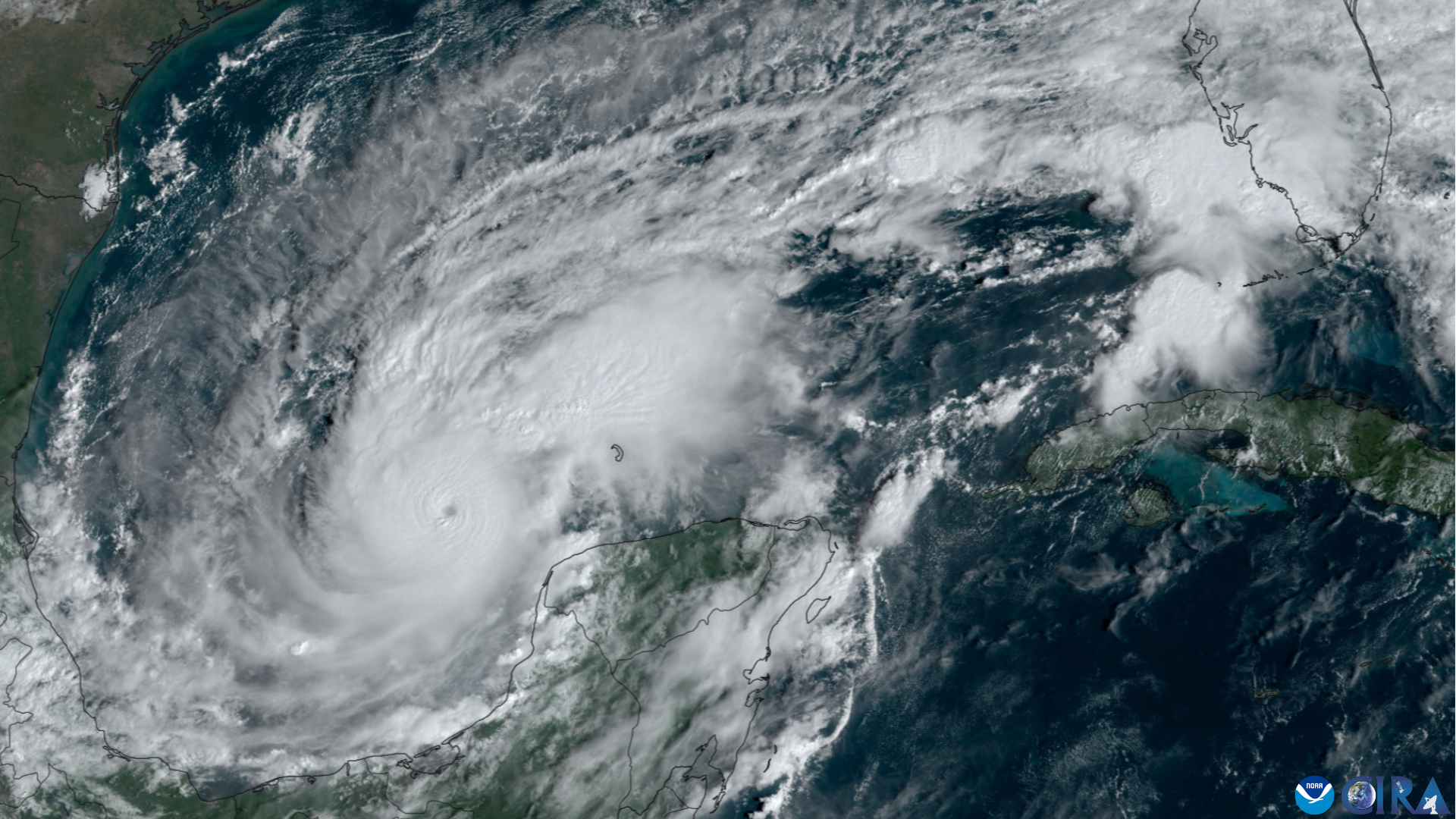
Why did it get stronger than forecast? The News Journal reports the wind shear that was supposed to weaken Isaias instead aligned with the storm's motion — which let the storm vent air away from its center more efficiently and strengthen more than anticipated. Forecasters believe Isaias could still be carrying winds around 115 mph as it approaches the area this evening. For reference, the News Journal noted that Hurricane Ivan made landfall at Gulf Shores, Alabama, as a Category 3 with sustained winds of 120 mph. Pensacola knows exactly what that looks like.
Surge: six to nine feet, starting this afternoon
The number that should drive every decision this afternoon is the surge. The National Weather Service forecasts storm surge inundation of 6 to 9 feet along the western Florida Panhandle coastline from Escambia County to Indian Pass — a full step up from the 5 to 7 feet in the earlier outlooks. Water levels will begin rising this afternoon, peak Friday night, and begin to subside after midnight, according to the NWS. The hurricane center says life-threatening storm surge is expected from the mouth of the Mississippi River all the way to Suwannee, Florida, and anyone under an evacuation order should leave immediately and follow guidance from local officials.
Rainfall adds a second flooding threat on top of the surge. All of Escambia and Santa Rosa counties are expected to see 4 to 8 inches of rain, which the News Journal reports could cause major flooding. This is not a storm where the wind is the only problem — the water comes twice, from the ocean and the sky.
The last hours to get ready: closures, crashes, and a city battening down
Friday midday turned into a cascade of closures and warnings across the Pensacola area. The one some locals take most seriously: Waffle House confirmed to the News Journal that all Escambia and Santa Rosa County locations closed at 10 a.m. today and will stay closed until conditions are safe — setting the informal FEMA disaster metric to "threatened" status. When the Waffle Houses close, the storm is not a drill.
Water is already being shut off on the barrier islands. Water service to all residents and businesses on Navarre Beach was cut at noon, and ECUA plans to shut down water to Pensacola Beach at 3 p.m. Escambia County Sheriff Chip Simmons asked Pensacola Beach residents to evacuate if they can, reminding them of the evacuation order for zones A and B and warning that law enforcement will shut down bridges when sustained winds reach 39 to 40 mph. County emergency management is also knocking down false rumors about bridge closure times circulating online — officials say closures are weather-dependent and can't be predicted with certainty, and that one bridge closing doesn't mean all of them are closed.

On the roads, it's already getting messy. Milton police closed Elmira and Willing streets at Highway 90 around noon to ease traffic from evacuees heading north, and the roads will stay closed until further notice. In Escambia County, both westbound lanes of Interstate 10 were blocked after an injury crash — Florida Highway Patrol got the call just before noon, troopers are diverting traffic around the wreck, and wreckers were on the way with the road expected to reopen within about 20 minutes. That is exactly the scenario emergency managers dread: the escape route clogged as the weather closes in.
Gov. Ron DeSantis, who expanded the state of emergency to 27 North Florida counties on Oct. 8, held a morning press conference in Pensacola saying the state and region are far better prepared for Isaias than they were for Hurricane Sally in 2020, with millions of resources staged for response and recovery. "Now's the time to make those decisions and execute those plans," DeSantis said, "so that we're able to get through this thing with minimal damage." State and local officials, he said, have been mobilized from day one because Isaias formed in the Gulf — there was never any question it would come ashore somewhere on the coast.
Tornadoes tonight, then a long Saturday
The tornado threat ramps up this afternoon and continues through the night, with the greatest risk east of Isaias's center — particularly across the Florida Panhandle into southern Georgia — before spreading north-northeast across parts of the Southeast on Saturday. A Tornado Watch is in effect for Pensacola and all of Santa Rosa County until 8 p.m. CT. Tropical-storm conditions are expected to begin in the warning areas within the next few hours, with the earliest arrival around 2 p.m. CT, and hurricane conditions are expected within the Hurricane Warning area this evening into early Saturday.
One more detail that says everything about where the Pensacola area is right now: street outreach teams — REAP, Pensacola Police, LIFT, and Opening Doors, the area's leading homelessness agency — have been canvassing for days to get unhoused residents to shelter, with ECAT offering free rides. When the outreach workers are doing street-level rounds in the afternoon, the storm is no longer a forecast. It's at the door.
Isaias is expected to begin weakening after landfall tonight and become post-tropical by late Saturday. We've been tracking this storm since the state-of-emergency declarations earlier this week — tonight is the night the Gulf Coast has been bracing for. The hurricane center's line for the afternoon stands: get to safety now, because in the next couple of hours, the window closes.
Sources
- Live: Tropical storm conditions reach Florida as Cat 3 Hurricane Isaias moves Pensacola News Journal · October 9, 2026
- Hurricane Isaias live updates: Florida impacts, path today Pensacola News Journal · October 8, 2026
- Will Hurricane Isaias make landfall in Florida? See expected impacts Pensacola News Journal · October 8, 2026