
MANILA, Philippines
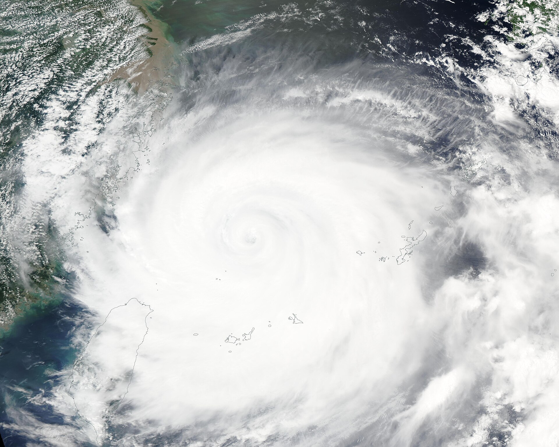
Super Typhoon Rosal is bearing down on extreme Northern Luzon from the east, a powerful storm that forecasters say will probably spare the Philippines a direct landfall while still bringing dangerous winds, heavy rain and the risk of flooding and landslides to the country's far north over the next two days. According to PAGASA, the Philippine Atmospheric, Geophysical and Astronomical Services Administration, Rosal — known internationally as Champi — was located 990 kilometres east of Northern Luzon as of 4:00 AM on Wednesday. BusinessWorld, reporting on PAGASA's Tropical Cyclone Bulletin Nr. 4, issued at 5:00 AM Wednesday, gave the same position and the same strength: maximum sustained winds of 215 kilometres per hour near the centre and gusts of up to 265 kilometres per hour, moving west-northwestward at 30 kilometres per hour.
Those numbers explain the words at the top of the bulletin. PAGASA reserves the super typhoon category for its strongest tropical cyclones, and a storm carrying 215 kph sustained winds is not a routine rainy-season system passing in the distance. PAGASA said strong to typhoon-force winds extend up to 780 kilometres from the centre of Rosal, a reach so wide that communities can feel the outer circulation long before the core comes anywhere near land. That is the central fact residents in the far north need to hold on to on Wednesday morning: the storm does not have to cross the coastline to change the weather, close the sea, soak saturated ground and make travel dangerous.
Who is under Signal No. 1
PAGASA has raised Tropical Cyclone Wind Signal No. 1 over seven areas: Batanes, the Babuyan Islands, mainland Cagayan, the eastern portion of Isabela, the northern and central portions of Apayao, the northeastern portion of Ilocos Norte, and the northeastern portion of Catanduanes. Under PAGASA's signal system as described in the bulletin, Signal No. 1 means winds of 39 to 61 kph could arrive within 36 hours and pose a minimal to minor threat to life and property. BusinessWorld reported the same list of areas in its coverage of the bulletin, underlining that the warning zone is concentrated in extreme Northern Luzon, with Catanduanes — further south in the Bicol region — also included on the northeastern side.
That list matters because it tells people where to act first. In Batanes and the Babuyan Islands, small island communities exposed to the open Pacific have the least shelter from a storm approaching from the east. In mainland Cagayan and eastern Isabela, the concern combines wind with the rain that PAGASA expects to fall over the next day and beyond. In Apayao and Ilocos Norte, the bulletin pairs wind signals with a specific heavy-rainfall warning. PAGASA also said the highest wind signal that may be raised during Rosal's passage is Signal No. 2 or Signal No. 3, so Wednesday's No. 1 should be read as a first warning, not a final ceiling. If the track or strength changes, the signal map can expand or rise, and PAGASA's next bulletins will be the authoritative source for those changes.
The rain may be the bigger local danger
For many communities under the signal, water may prove more consequential than wind. PAGASA warned that 50 to 100 millimetres of rain is expected in Ilocos Norte, Apayao and Cagayan within the next 24 hours, and BusinessWorld reported that the heavy rainfall outlook may extend to Friday. PAGASA said flooding and landslides are possible in affected areas. That risk is not abstract in Northern Luzon, where steep terrain in Apayao and the Cordillera foothills, river systems in Cagayan Valley, and coastal lowlands can each turn a day of heavy rain into a different kind of emergency.
Fifty millimetres is enough rain to swell streams and make some roads difficult; 100 millimetres falling in a short period can overwhelm drainage, trigger soil movement on slopes and cut off low-lying neighbourhoods. PAGASA's warning therefore asks residents to think beyond their own street: a house that is not in a flood zone can still be isolated if a bridge, a mountain road or a river crossing becomes impassable, and a slope that held through earlier rain can fail after hours of new soaking. Local disaster officials typically use bulletins like this one to decide on pre-emptive checks of evacuation routes, river levels and hillside communities, and residents should follow the instructions of their local governments alongside PAGASA's national bulletins.
No direct landfall does not mean no impact
PAGASA said Champi is unlikely to make direct landfall in the Philippines. That forecast, reported by BusinessWorld, is genuinely good news compared with a super typhoon crossing Luzon at full strength — a direct hit from a 215 kph storm would be a far more destructive event. But forecasters were careful, in the same bulletin, not to let the no-landfall line become a no-worries line. PAGASA said Rosal's outer circulation and cloud bands will still bring strong winds and rain to parts of Luzon, especially in the north, as the storm makes its closest approach.
The geometry explains why. A centre passing offshore can still drag its southern and western rain bands across land for many hours, and a wind field extending up to 780 kilometres from the centre does not respect the difference between a technical landfall and a near miss. PAGASA also warned that gale-force gusts are expected today from the northeasterly windflow and Rosal's periphery across wide areas beyond the signal zone, including Ilocos, the Cordillera, Cagayan Valley, Bicol, Romblon, Eastern Visayas and parts of Mindanao. In other words, Wednesday's gusty conditions in places far from Batanes are not a separate weather story; they are part of the same large circulation interacting with the windflow around it.
The Thursday-to-Friday timeline
The next 48 hours are the window PAGASA is asking the north to watch most closely. According to PAGASA, Rosal's closest approach to extreme Northern Luzon is expected between Thursday and Friday afternoon, as it continues west-northwestward before turning away. The heavy rainfall outlook may extend to Friday, BusinessWorld reported, which means the flood and landslide risk can linger even after the strongest gusts at a given location have peaked — rivers often rise after the rain that feeds them, and saturated slopes can fail later in the event.
PAGASA expects Rosal to exit the Philippine Area of Responsibility by Friday evening or early Saturday morning. Until then, the practical advice embedded in the bulletin is straightforward: secure loose objects that Signal No. 1 winds can move, avoid unnecessary sea travel where local authorities warn against it, stay away from swollen rivers and floodwater, and treat landslide-prone roads with particular caution after heavy rain. Fishers and small-craft operators should follow the latest PAGASA and Coast Guard advisories for their specific waters rather than relying on a morning headline, because conditions at sea near a super typhoon can deteriorate faster than conditions on land.
Rosal is reported to be the Philippines' 18th tropical cyclone of 2026 and the first of October, having entered the Philippine Area of Responsibility on Tuesday — a reminder, late in October, that the country's typhoon season does not end on a tidy calendar date. For readers following severe weather on both sides of the Pacific, the pattern will feel familiar from our coverage of the nor'easter and Invest 93L flooding the Carolinas and Mid-Atlantic: the official track line is only part of the story, and the water a large storm pushes and drops around that line is often what people actually live through. Follow the latest bulletins on the Previously news front as PAGASA updates Rosal's position, signals and rainfall outlook through Friday.
Sources · 3 sources
- PAGASA — Tropical Cyclone Bulletin Nr. 4 for Super Typhoon Rosal (Champi), issued 5:00 AM October 21, 2026, via ReliefWeb: position 990 km east of Northern Luzon at 4:00 AM, 215 kph sustained winds, 265 kph gusts, Signal No. 1 areas, rainfall and timeline (October 21, 2026)
- BusinessWorld — Reporting on PAGASA's bulletin for Super Typhoon Champi (Rosal): strength, signal areas, heavy rainfall outlook and expected exit from the Philippine Area of Responsibility (October 21, 2026)
- ReliefWeb — Publication of PAGASA Tropical Cyclone Bulletin Nr. 4 for Super Typhoon Rosal (Champi) (October 21, 2026)